Earthquakes
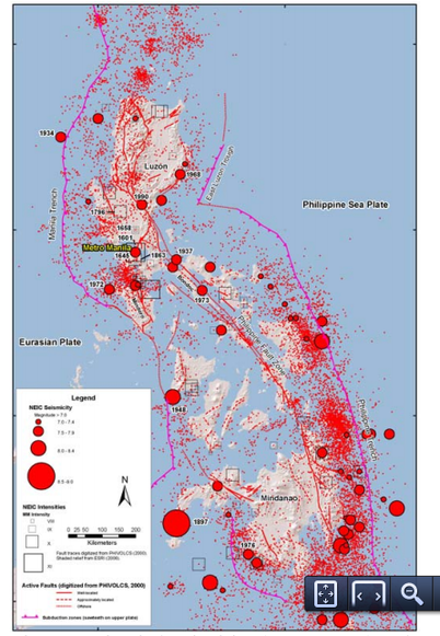
With a complex system of faults surrounding the area, Manila and the rest of the Philippines are very vulnerable to large scale earthquakes. The map on the left shows the historical seismicity of the country during the period 1600 to 2006 (Wong et al). It is clear that the country experiences a large number of seismic activity, especially concentrated along the faults.
The location of Luzon Island along a major plate boundary suggests that the level of seismicity in the city of Manila can be high, and that earthquakes of magnitude 7 or over are very likely. It is impossible to predict the exact timing of earthquakes, but we can make educated guesses using the history of past seismic activity. Manila has been heavily damaged by earthquakes more than six times in the last 400 years (Nelson et al, 2000). The average return period of high damage earthquakes is estimated to be around 80 years (Miura et al., 2008).
Experts from the Philippine Institute of Volcanology and Seismology predict that if the West Valley Front cracks along the eastern side of Metro Manila, a destructive earthquake of M 7.2 during the current generation is highly likely (Luces, 2013). A high energy earthquake like this can shake the earth a hundred kilometers away from the epicenter, and can cause destructive damage in the whole of Metro Manila and its surrounding provinces.
Areas near Marikina Valley and on the edge of Manila Bay will experience the largest shaking, due to the softer ground that lies underneath. This softer material also poses the risk of liquefaction, where loose sandy sediments act like liquid and deform. This can have destructive damages on poorly constructed buildings in the region.
Below are two examples of major earthquakes in the history of Manila.
1645 Luzon EarthquakeThe largest earthquake in the history of Manila was a Magnitude 7.5 earthquake that occurred on 30 November 1645. It is suggested that the 1645 earthquake was caused by the interaction of the San Manuel and Gabaldon faults. Damage in Manila was severe, “almost everything crumbled” and the cathedral was destroyed. The number of deaths ranged from 600 to 3,000 (Jagor et al., 2004). Aftershocks continued in the area for days, causing further deaths and destruction.
|

Image of a demolished building from the 1990 earthquake.
|
1990 Luzon EarthquakeA more recent example is the Magnitude 7.7 earthquake that took the lives of 1,666 people on 16 July, 1990. Bagulo City was most damaged by the minute-long shake, but the city of Manila was also heavily affected. The shaking was caused by a horizontal left-lateral strike-slip fault motion which had a maximum displacement of 6.2m (IRIS). Regional scale landslides and liquefaction followed the shaking and affected a large area in Northern and Central Luzon. The seismic activity also triggered the awakening of Taal Volcano and and Mount Pinatubo, which erupted in May 1991, further affecting the region with a blanket of volcanic ash.
|
Volcanism
 Eruption of Taal Volcano
Among the islands of the Philippines, Luzon Island contains the most active volcanoes. The Macolod Corridor in northern Luzon is a zone of active volcanism. Out of the 25 volcanoes on Luzon, the one of most impact on Manila city is Taal Volcano. This is a caldera volcano located 60km north of Manila City, and is known to be the most active and dangerous of the many volcanoes on the island. It is known for its violent eruptions in spite of its low altitude (Yokoyama et al., 1975). In its recorded history since 1572, there were at least 6 deadly eruptions that damaged the region with powerful pyroclastic flow and destructive tsunamis (Volcano Discovery). In 1911, a large eruption of Taal killed 1334 people and covered Manila City in volcanic ash.
 Photo of 1991 Mt. Pinatubo eruption
Another active volcano important to the city of Manila is Mt. Pinatubo. This volcano is located 90km northwest of Manila, and is famous for the second largest volcanic eruption of the Twentieth century, which occurred in June 1991 (Rosenberg, 2010). Due to this eruption, 800 people were killed and 100,000 people were left homeless. Following the eruption, 10cm thick ash covered an area of 2000 square km, and between 15 and 30 million tons of sulfur dioxide was discharged into the atmosphere, affecting global atmospheric temperatures for the following few years.
Flooding

Situated on extensive flood plains with little slope, the coastal city of Manila is constantly in danger of flood. Seasonal monsoon rains and tropical storms are the main causes of flood. The most flood-prone areas in Metro Manila are the Kamanava area, Pasig-San Juan River (Core Area), Pasay-Parañaque area, Marikina River area, and Taguig-Pasig area (Liongson, 2008).
|

In a study conducted by Liongson, the probabilities or annual frequencies (return period) of maximum rain fall in Manila for a 1-hour period and 1-day period were estimated to be the above values. Substantial rainfall is quite frequent in the area, which is the main reason for the large number of floods every year.
|

One recent example of a catastrophic flood in Manila was the August 2012 flood. On August 7, Manila got 504 mm of rain in a day, followed by more torrential rain throughout the week (CNN, 2012). The flood caused nearly a million citizens to evacuate, and triggered landslides that killed 9 people. By Wednesday, more than 60% of the city was under water (BBC, 2012).
The storm was caused by a large movement of the southwest monsoon caused by the pull of Typhoon Saola. As a result of a week of heavy precipitation and storm, 95 people were killed and over 8,000 homes destroyed. Total damage to the Philippines was at least $14.3 million USD.
The storm was caused by a large movement of the southwest monsoon caused by the pull of Typhoon Saola. As a result of a week of heavy precipitation and storm, 95 people were killed and over 8,000 homes destroyed. Total damage to the Philippines was at least $14.3 million USD.
